
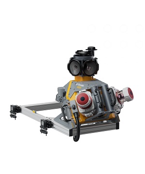
Description
The Trimble® MX90 system is part of a complete field-to-finish mobile mapping solution
that combines leading-edge hardware with intuitive field software and an integrated office software workflow.
State-of-the-art GNSS and inertial technology, easy to install and simple to operate.
With leading-edge image and LiDAR capabilities and intuitive field software.
Key specifications
The Trimble MX90 captures rich data for modeling and high-density point clouds,
ideal for large survey and engineering projects.
Specifications
Weight
Sensor unit 37 kg
IP rating
Sensor unit IP64
Spherical camera
72 MP (6 X 12 MP)
Planar cameras
2 X 12 MP side facing, 1 X 12 MP backward/downward facing
Laser effective measurement rate
Up to 3.6 MHz
Scan speed
500 scan/sec
Embedded Trimble GNSS-inertial system
Trimble field-to-finish workflow
Reviews
There are no reviews yet.