
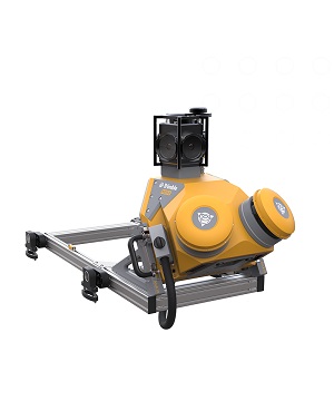
Description
The Trimble® MX50 mobile mapping system delivers accurate point clouds
with immersive imagery for easy asset management, mapping and maintenance.
Effortlessly capture, process, extract and share data with proven
field‑to‑finish workflows for asset mapping and asset data management.
Key specifications
Powered by a Trimble precise laser system and 360-degree panoramic camera,
the MX50 handles data flows seamlessly, at top speed, with high accuracy.
Specifications
Weight
Sensor unit 23 kg
IP Rating
Sensor unit IP64
Spherical camera
30 MP (6 x 5 MP)
Laser effective measurement rate
Up to 960kHz
Scan speed
240 scan/sec
Embedded Trimble GNSS-inertial system
Trimble field-to-finish workflow
Reviews
There are no reviews yet.